Signed in as:
filler@godaddy.com

The clearest view of the rural landscape comes from above—imagery captured by satellites, aircraft, drones, and land‑based sensors, then transformed into intelligent 3D geospatial information. This is EkoSight’s core competency: using advanced photogrammetry, multispectral analysis, and AI‑driven feature extraction to reveal a landscape’s structure, health, and change over time. We are proud users of Esri’s ArcGIS software, and we build information products that move seamlessly from our GIS to yours. ArcGIS offers powerful tools for visualizing and analyzing our content, and if you’re new to GIS, we can help you get started with the right solution. We also support other GIS platforms or provide standard digital files—just let us know your preference.
Seeing is believing -- From our GIS to Yours

EkoSight provides the critical geospatial foundation data that modern planning and conservation depend on—updated image maps, elevation models, contours, land‑cover classifications, and refreshed feature layers such as roads, buildings, and streams. These layers form the base for accurate analysis, helping communities and land stewards see change clearly and make informed decisions with confidence.
EkoSight builds on high‑resolution foundation data to deliver powerful terrain analysis for rural landscapes. We create specialized products such as impervious‑surface maps, erosion‑risk models, wetland delineations, riparian‑buffer assessments, and habitat‑quality evaluations for key species. These tools help measure the environmental impacts of proposed development and reveal meaningful environmental and agricultural trends across any area of interest.
EkoSight’s multispectral drone capabilities allow us to detect a wide range of vegetation‑health issues across both agricultural fields and natural ecosystems. By analyzing subtle changes in chlorophyll, moisture, and canopy structure, we can identify crop stress from fungal pathogens, spot early signs of pine‑bark‑beetle infestation, and flag invasive species before they spread. These insights give land stewards an early warning system—helping protect crops and forests.
EkoSight’s multispectral drones give land stewards a powerful way to map invasive plant species. With red‑edge and near‑infrared signatures, we can distinguish problem species such as phragmites in wetlands, Japanese knotweed along riparian corridors, and early emerging garlic mustard in forest understories. These spectral differences stand out clearly from surrounding vegetation, allowing us to pinpoint infestations early to support targeted eradication.
EkoSight’s 3D Digital Twins map reality with stunning clarity, capturing the true shape and character of both built and natural environments. They provide essential context for the here and now—dynamic models that can be explored, measured, and understood from every angle. As living digital containers, they link to asset records, maintenance guides, and feature data, allowing places to be visited, inspected, and integrated into plans without ever leaving the office.
Ekosight celebrates the irreplaceable beauty and heritage found across rural landscapes. From the wild rice stands found in quiet wetlands that have been harvested by Native Americans for centuries to historic cemeteries, fragile sand dunes with endangered flora, and pristine trout streams, these places hold stories of culture, ecology, and renewal. These are places to protect, and EkoSight is committed to helping rural stewards see and safeguard these treasures that nourish our lives.
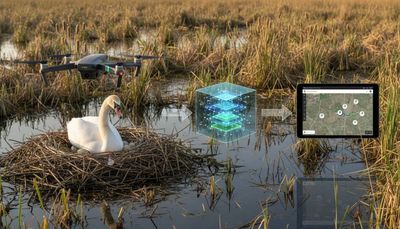
Deep Learning is the part of AI that helps EkoSight see what matters in imagery. By training specialized models, we can automatically detect invasive plants, track land‑cover changes, locate swan nesting sites, or even count and map picnic tables in a park. We use proven models or build our own, refining them so they can be used again and again. This kind of GeoAI is fundamental to our work—saving time, improving accuracy, and delivering real value to the rural stewards we serve. Regardless, we always have a human in the loop to verify our AI's results.
Affordable - Our work is priced only to recover direct costs
Tailored – We design every project together so it fits your needs perfectly.
Practical – Rural landscapes are working places, not just preserves, and we can help with your productivity in sustainable ways.
Dedicated - Together, we help rural landscapes flourish in resilient ways
